In this last leg of our trip, we’ll pass through Skamania, the Bridge of the Gods , the Washington side of the Pacific Crest Trail, then North Bonneville, Bonneville Dam, Bonneville Hot Springs, Beacon Rock and Cape Horn Trail, returning at the Glenn Jackson Memorial Bridge, which links Vancouver to Portland.

Bridge of the Gods to I-205
On the east side of the Bridge of the Gods is Stevenson and the west side North Bonneville. Near North Bonneville is the Franz Lake National Wildlife Refuge, a true wildlife sanctuary where wildlife and plants remain undisturbed by human activity. The lakes can be observed from a viewing platform just west of Skamania.

Bonneville Hot Springs Resort near North Bonneville is a popular spa featuring geothermal steam baths, heated from the molten lava of the subduction zone, some 40 miles below. It’s been an historical landmark since 1897.

North Bonneville has 12 miles of community walking/bike path routes around the Gorge. The Heritage Trails system will eventually consist of four color coded interpretive routes all originating at a common trailhead… the Downtown Trail Station.

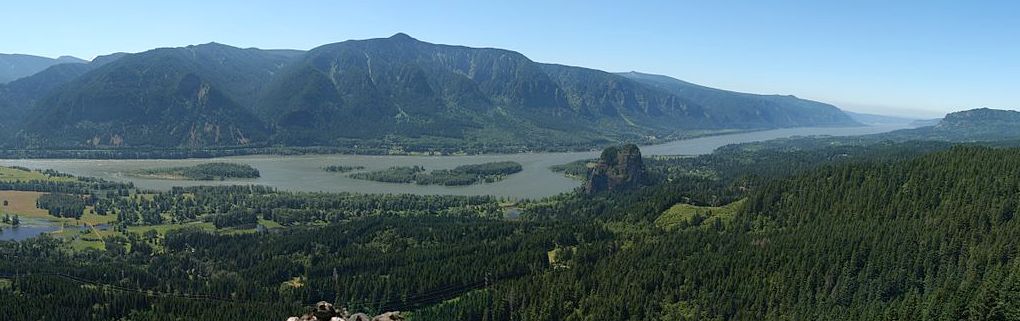
Located three miles west of Bonneville Lock and Dam, make sure to stop at Beacon Rock (MP 35), which is the exposed core of an ancient volcano standing more than 800 feet above the Columbia. The rock is the largest geologic formation of its kind in the nation. Hike to the top for an impressive view where you can see for hundreds of miles in all directions. The adjoining Beacon Rock State Park offers camping, picnicking and hiking.

The USGS has mapped a history of 215 different landslides (maps) between Prindle and Carson in Skamania County. About a fifth of the slides the researchers observed are more than 1,000 years old. Around a dozen occurred in the last two decades or are currently moving.

The big Bonneville Landslide, which blocked the Columbia River and formed “The Bridge of the Gods” may have happened about 1450 AD or even triggered by the last big Cascadia subduction zone earthquake in 1700.

Looking North from Cascade Locks Oregon, you see the Red Bluffs landslide (right) and the Bonneville landslide (left) below the sharp-peaked Table Mountain. Wildflowers on the south-facing Washington side, start blooming as early as March and include several species only found in this region.
No trail showcases the Columbia River like the Cape Horn trail. Most of the trail is volunteer-built, and it is one of the Washington Trail Associations‘ signature projects for 2011. Begin the Cape Horn hike by crossing Salmon Falls Road to the trailhead. Take the fork to the right at the start of the trail. It’s about 8 miles round trip. The main parking area is at Salmon Falls Road and Hwy 14. The upper trail begins on the west side of the parking lot.

Architect John Yeon in 1937, penned the “Conservation and Development of the Scenic and Recreational Resources of the Columbia Gorge”—in effect, the area’s first environmental impact statement. He later teamed with Nancy Russel (left) and others to save the Gorge as we know it.
In the early 1980’s Friends of the Gorge founder Nancy Russell was so inspired by the sweeping vista from atop Cape Horn that she embarked on a 20 year effort to protect the area for all the public to enjoy. Bruce and Nancy Russell purchased land originally slated to become a private subdivision and worked with the Trust for Public Lands to transfer the land to the Forest Service.
Additional parcels were similarly acquired and transferred as the Friends of the Gorge worked in partnership with the Columbia Land Trust, Trust for Public Lands and the Columbia River Gorge National Scenic Area.

Here are 20 reasons to visit the Washington side of the Columbia River Gorge.
The conservation effort is growing. The Columbia Land Trust has conserved more than 9,000 acres near Mount St. Helens with another 3,500 acres around the Klickitat River near the Columbia River Gorge area. The land trust aims to restore some 3 miles of river habitat downstream of the old Powerdale Dam in Oregon near Hood River.

We’ll end out journey at the Glenn Jackson Memorial Bridge.

Glenn Jackson (1902 – 1980) was a newspaper man an influential transportation planner Oregon. He was chair of the Oregon State Highway Commission, later known as the Oregon Transportation Commission and directed the planning and construction of 700 miles of freeway and more than 800 bridges including the Fremont, Astoria–Megler, and Marquam bridges.
Jackson later founded 1000 Friends of Oregon, an organization dedicated to the protection of Oregon’s quality of life through land-use planning.
Hope you enjoyed our journey through the Columbia River Gorge.
This natural wonder has been shaped over millennia, and over multiple cataclysmic floods such as the Missoula Floods 10,000 years ago. It was the spiritual and trading center for native Americans, and has been harnessed as an economic powerhouse for fishing, logging, transportation and electricity that shaped the Northwest. Most recently it has been preserved by visionaries and defended by people of Washington and Oregon who know and love it.
The battle between exploitation and preservation will continue. With commitment and vigilance, the Columbia Gorge will continue to lift spirits 100 years from now.