This part of the trip includes about 10 miles of unfinished trail. Mitchell Point, and the acclaimed “5 window tunnel” which cut through rock above the river were blasted away during the construction of Interstate 84 just below it along the river. The Mitchell Point Tunnel is the missing link.
Since little remains of the original route, both car and bike traffic must take the freeway along parts of this section.
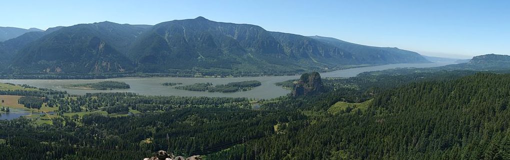
But before we leave Cascade Locks, we need to take in the sights. They include Bonneville Lock and Dam, The Locks, Canal and Sternwheeler, and Marine Park.
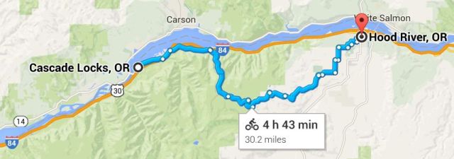
This leg will pass Starvation Creek State Park, Viento State Park, Mitchell Point (near the removed tunnel), Ruthton Point and the city of Hood River. About halfway down this leg, at Wyeth, we’ll rejoin I-84 until we get to Hood River.
Grant McCombie reviews some of the attractions at Cascade Locks.
Cascade Locks to Hood River
36. The Locks, Canal and Sternwheeler
Lewis and Clark camped here October 30 – November 1, 1805.
Clark took four canoes up the rapids on April 11, 1806, “with a great deal of labor; some of the canoes were unavoidably damaged in the process.”
Early travelers following the Oregon Trail were forced to portage around the impassable rapids here or go overland via Mt. Hood’s Barlow Road, a steep, dangerous toll road.

In 1864, the Oregon Portage Railroad became the first railroad in the Northwest. It ran between what is now Bonneville Dam to the Cascade Locks and was operated by the Oregon Steam Navigation Company.
The Oregon Pony portaged steamboat passengers and goods past the Cascade Rapids. The original locomotive is in Marine Park, near the Cascade Locks Historical Museum.

Construction on the first locks began in 1878 and were completed on November 5, 1896. Although the rising waters of the Bonneville Lock and Dam submerged most of the locks in 1938, Cascade Locks, the city, remains as a vital community in the heart of the Columbia River Gorge.
Hikes include the Gorge Trail 400 which follows I-84 and the Columbia River. You may continue onto Eagle Creek trail 440, one of the most popular hikes in the Gorge. Highlights include Punch Bowl Falls where water spills 25 feet into a blue-green pool, High Bridge which traverses 150 feet about the creek, and Tunnel Falls where the trail passes in a tunnel under a tower of falling water.
Cascade Locks is a biker’s paradise with a variety of trails. A bike route between Troutdale and Cascade Locks, a 31 mile route without using I-84, opened in 2013. Download a bike map of this segment that includes an elevation profile.
Short sternwheeler journeys are available at Cascade Locks from Spring to Fall. The sternwheeler winters in Portland.
37. On to Frontage Rd

We’re headed east, out of town. The new Easy Climb Trail is straight ahead, but we’re going to take a right here, at the exit towards Highway 84. We’re going to travel past (under) 84 a short distance to Frontage Road, a 2-lane county road that parallels I-84 and the historic highway.
The Oxbow Fish Hatchery, 1 mile east of Cascade Locks, is presently used for interim egg incubation and early rearing of Coho, Spring Chinook and Sockeye. No adult fish are collected or spawned at Oxbow and there are no fish released at this facility. Rearing and release strategies are designed to limit the amount of interactions between hatchery and naturally produced fish.

The Easy Climb Trail (video) is a two-mile loop that retools vacant Port of Cascade Locks riverfront property into a beginner-friendly ride with river views.

We’ll merge back with I-84 a few miles east of Cascade Locks from our Frontage Road route. Bikers may want to take the Wyeth Rd/Herman Creek exit just before the freeway entrance for a quieter two-lane backtop.

Starvation Creek State Park (I-84 Exit 55)

Starvation Creek State Park, a day-use park, connects to numerous trails including Mt. Defiance and Starvation Ridge trails. It was named Starvation Creek because a train was stopped there by snow drifts although no one actually starved there. Heading east, you can trek along a remnant of the Historic Columbia River Highway State Trail to Viento State Park and campground.

The dotted lines on the Historic Trail map (above) show sections that still need work. The plan is to connect the dots by 2016. You can’t drive on the Historic Trail – it’s for hikers and bikers only.
Viento State Park Exit 56

Viento State Park, pronounced vee-EN-toe, is Spanish for wind. Viento is next to a working railroad line so visitors can expect to hear train horns throughout the day and night. A one-mile, fully handicapped accessible trail from Viento to the Starvation Creek waterfall takes you along a section of the Historic Columbia River Highway, now a hiking trail.

Mitchell Point Exit 58

Mitchell Point is a cliff that overhangs the Columbia River. In the 1955 when Interstate 84 was built along the Columbia River the now-demolished Mitchell Point Tunnel was permanently closed.
It’s a short but steep hike to Mitchell Point, which covers a lot of scenery in 2.6 miles. Downstream is Viento State Park and Starvation Creek State Park.

The Mitchell Point tunnel originally connected the two intact historic highway segments on either side of Mitchell Point. The state closed the 390 foot long “Tunnel of Many Vistas” in 1953 because of increased vehicle size and rockfall hazards.

Peg Willis explains that the Mitchell Point Tunnel with its five windows carved through basaltic rock, is no more. It was a huge engineering challenge and contractors with years of experience would have no part of the project.

In 1966, because of crumbling conditions, the tunnel was blasted from the cliff. Tooth Rock Tunnel, at milepost 41 on Interstate 84, offers an alternative route.

The Mitchell Point Overlook is easily accessible from the eastbound lanes of Interstate 84. The viewpoint offers good views of the Columbia River, Washington State’s Drano Lake, Washington State Highway Tunnels, and remnants of the old Broughton Flume.

The nine-mile-long Broughton Flume operated from 1923 to 1986. Water came from the Little White Salmon River and transported as much as 150,000 board feet of lumber per day from the mill in Willard to the finishing mill in Hood.
Ruthton Point (Milepost 63)
Ruthton Point is a cape jutting into the Columbia River at River Mile (RM) 166, about 2.4 miles downstream from the City of Hood River and about 4.3 miles from White Salmon, WA, across the river. There’s no convenient exit on I-84 heading East, however.
The Columbia Gorge Hotel (Exit 62)

Built in 1921 by timber tycoon Simon Benson, the The Columbia Gorge Hotel, the “Waldorf of the West” is perched on a scenic cliff, with sweeping views of the Columbia River as well as great accommodations and dining. You take the Hood River exit then backtrack on Frontage Rd to get to the hotel, which is west of downtown Hood River.
Hood River Exit 62

Hood River (Westside)
Hood River is the seat of Hood River County and is about 30 miles north of Mount Hood, the tallest peak in the state. It is across the Columbia River from White Salmon, Washington.
South of the city, the Hood River Valley is known for its apples, pears, and cherries. The 35-mile Fruit Loop provides the chance to gorge out on cherries, blueberries, and apples.

Businesses include employee-owned Full Sail Brewing, sports equipment manufacturer DaKine, vegetarian food manufacturer Turtle Island Foods, producer of Tofurky, and dozens of Bed and Breakfasts.
The Hood River Railroad is a scenic railroad which passes by numerous fruit orchards on the way up the bluff. The four-hour, 21 mile scenic tour terminates at Parkdale before returning.
The Excursion Train offers light concessions with dinner and brunch trains providing meals. Cars are heated and the dome cars are air conditioned.
Other Hood River attractions include the Western Antique Aeroplane & Automobile Museum (WAAAM), the History Museum of Hood River County, and the International Museum of Carousel Art.
You can also take the short drive across the bridge to Swale Canyon — a hidden gem along the Klickitat Rail Trail in neighboring Washington.