Let’s head back to Portland down the Washington side. We’ll take Sam Hill Memorial Bridge over the Columbia to Washington at Biggs Junction.
We’ll check out the Goldendale wind turbine farms, the Goldendale observatory, the Maryhill Museum of Art, Stonehenge and pass through Columbia Hills State Park, Dougs Beach, a windsurfing and sailboarding location, and Lyle.

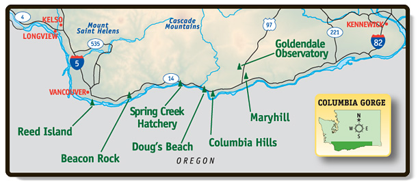
Washington State Parks along the Gorge include Columbia Hills, Doug’s Beach, Spring Creek Hatchery, Beacon Rock and Reed Island State Park.
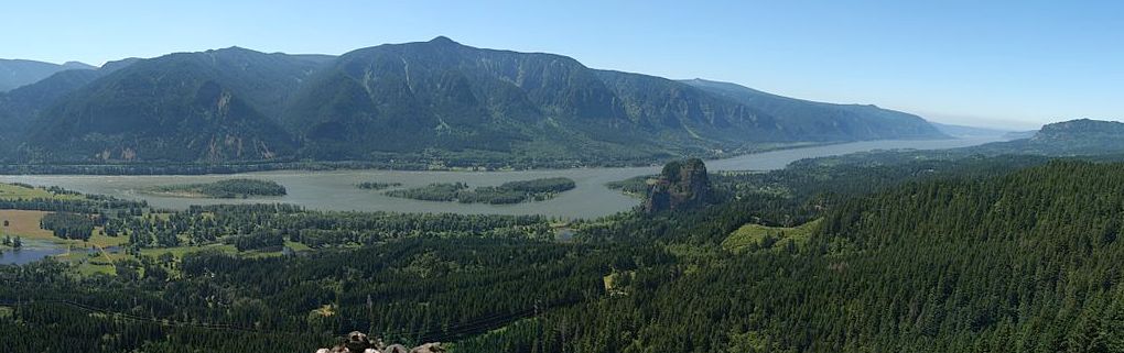
The Columbia River Gorge was formed over millions of years, but huge floods from ice-age dams did most of the carving. About 20,000 years ago, during the final stages of the Ice Age, Glacial Lake Missoula was formed covering eastern Washington to western Montana.
The cycle of floods that reshaped the landscape from the Idaho panhandle all the way to the Pacific Ocean represented a series of events—each one of them ranking as one of nature’s truly catastrophic occurrences. Lake Missoula held as much water as Lake Erie and Lake Ontario combined. The water flow, when it was breached, has been calculated to be 10 times the combined flow of all the rivers on Earth.
Geologists estimate that a cycle of flooding and reformation of the lake lasted an average of 55 years and that the floods occurred several times over the 2,000-year period between 15,000 and 13,000 years ago.
A Discover Pass is required for vehicle access to Washington state parks for day use. Here are other Recreation Pass Programs you might want for traveling around the Northwest. The best deal, if you’re over 62, is probably the $10 Interagency Senior Pass which waives most day use fees.
Biggs Junction to Lyle
Maryhill State Park is a 99-acre camping park with 4,700-feet of waterfront at the base of the Sam Hill Memorial Bridge on the Washington side.
Stonehenge Memorial,is three miles east of the Maryhill Museum just off Highway 14 at the original Maryhill town site, named after the wife and daughter of Sam Hill, who purchased land and envisioned a community there shortly after the turn of the 20th century. The Stonehenge replica was commissioned by Sam Hill in 1918 as a memorial to those that died in World War I.

On June 8, 1918, when a total eclipse of the sun was predicted, the best viewing point was in the vicinity of Goldendale and the altar stone was aligned to the astronomical horizon. The The Goldendale Observatory is inside Goldendale Observatory State Park. The 24.5 in (620 mm) Cassegrain reflecting telescope was built by four amateur astronomers. It’s off Hwy 97, and near the town of Goldendale.
Maryhill Stonehenge, Washington from Northwest Aerial Imagery
Stonehenge is near the Maryhill Museum, which celebrates its 75th anniversary in 2015.
When it opened to the public in 1940, Time magazine called it “the world’s most isolated art museum.” While the surrounding population has grown, Maryhill Museum of Art remains a rural anomaly. Sam Hill’s agricultural community was never established. “What in the Sam Hill”, is a popular expression in the Northwest.
Further downriver, Wishram, WA, just across the river from Celilo, was a thriving community occupied by native peoples for ~ 15,000 years, as a center for fishing and exchanging goods.
Most of the native populated areas were closer to the river and convenient to fishing, but the lower area was flooded in 1957 by water backed up behind The Dalles Dam. When Lewis and Clark explored the area in 1805 and 1806, they noted a village of “26 Mat Lodges”.
The unincorporated town became known as Fallbridge around 1914, in recognition of the SP&S Railway, which crossed the Columbia on the Oregon Trunk Rail Bridge, which is now owned by the BNSF Railway. The name was changed to Wishram in 1926.

This Klickitat County area began forming as far back as the Miocene, (roughly 12 – 17 million years ago) depositing thick layers of Columbia River Basalt. The Cascades Range was forming, it slowly moved the Columbia River’s course north to its current location.
The Columbia Gorge is an American Viticultural Area for wine growers due to the unique climate and geography between Hood River and White Salmon in the west, to Biggs Junction and Goldendale, Washington in the east. The 40 mile section includes four counties; Hood River and Wasco counties in Oregon, and Skamania and Klickitat counties in Washington.
Fun Things to Do on the Washington Side include wine tasting. This Washington Wine Map shows some of the highlights.

Horsethief Butte Trailhead is one of numerous vistas of the primordial scene. It’s part of Washington’s expansive Columbia Hills State Park, and looks over what is now Celilo Lake.

We’re traveling on Washington’s State Route 14, a 180 mile-long state highway that travels on the north side of the Columbia River, opposite Interstate 84. It will take us to Lyle, but you can cross over at The Dalles bridge here.

Doug’s Beach State Park, 3 miles east of Lyle, is one of the premier windsurfing sites in the Columbia Gorge and is rated for advanced sailors. The park offers ten unsheltered picnic tables and three porta potties, but no water, dump sites and precious little parking. Big swells are formed by the surge of current forcing its way through this narrow channel, only 1/4 mile wide at this point.
It also has some hiking, too, because the state’s 400 acres of public land extends well inland above the river and reaches the rim of the gorge. But there are no trails and the hills are extremely steep. Downstream on the Oregon side is Rowena Crest.
Lyle is at the mouth of the Klickitat River. The Klickitat is one of the longest undammed rivers in the northwest. In 1986 the lower 10 miles of the Klickitat River were designated recreational under the Wild and Scenic Rivers Act, to preserve its free-flowing condition. Immediately across from Lyle is Oregon’s Mayer State Park.

The area is also home to six boutique wineries: Cor Cellars, Domaine Pouillon, Jacob Williams Winery, Klickitat Canyon Winery, Memaloose, and Syncline. The Klickitat Trail follows the river on an abandoned railroad grade from near Goldendale.